Getting around Seoul 1001
Updated: 2018/3/31
Table of Contents:
For many travelers, taking public transit can seem a bit confusing or daunting. I'm here to say the opposite. Public transit is probably one of the best parts of exploring a metropolis, and can easily make your life and travel better through some simple tips. So here's my personal (possibly a bit too comprehensive) guide for traveling about in Seoul.
Using subway/bus:
For individuals who aren't from cities with widespread public transit, going to a city like Seoul where you can go almost anywhere with transit may seem overwhelming. Once you familiarize yourself with the system, it starts to become very easy, and if you can master using the subway in Seoul, you can master it anywhere else in the world. Here are some of my tips to alleviate any worries you have about the metro:
0. Buy a T-money card
- No matter how long you plan to stay in Korea, your T-money card is probably the most important object in your possession. And likely one of the more expensive. On average, if you plan on visiting 3 places a day, taking subway, then you’re likely to spend about 6000-10000 Won per day for transportation. The estimate I go by is a week of vacation in Korea = 50000 Won in transit. If you want to make T-money your go to, pretty much all convenience stores will accept T-money as payment. Just look for this T sign outside before you enter.
1. There is English EVERYWHERE
- If you can read English, you can ride the subway. English is so abundant within Seoul subways that anyone can use it. Pretty much any sign that has information on it has English text, and for you, that makes it easy to see where you are going. Pretty much all trains announce the next stop in Korean, English, Japanese, and Chinese. And unlike a lot of American subways, yes, the Seoul intercom is very very audible. You will never miss an announcement.
2. Subway lines
- When referring to the subway lines, you can refer to them either by color or by number. And there are a lot. But don't be overwhelmed. You will quickly find yourself generally using the same lines over again, and ignoring the rest of the map. For short term travelers who plan on staying only in Seoul, you will end up using only a fraction of the full system.
- Unlike New York, Seoul subway stations support both directions, so you don't have to worry about checking if you are about to walk into an "Uptown bound" train when you need a Downtown bound train. But how to know which train to take then? A good rule of thumb is to know one or both of the endpoints for the train line. For example, on the Orange line (#3), if you are riding from Apgujeong station, trying to get to Daechi station, you would ride the train bound for "Ogeum" (The other direction would be to "Daehwa.")
- The absolute most important line is the #2 Green line. It goes in a full circle, traveling through Seoul's important business districts, major universities, residences, and hip spots. But with great coverage comes great crowds. Always be prepared to stand on the Green line.
3. Use the entrance/exit numbers
- True for all the major cities of Asia, entrance/exit are named and numbered. When you are navigating on maps, try to look for the best exit to come out of. It might save you crossing the street when you don't have to.
- If you are meeting someone at a station, always try to pick an exit number to meet at. It is better to pick an exit number ahead of time than doing the awkward, "I'm here. Exit 3" "Me too. But exit 6" on the opposite sides of the subway station.
4. Avoid rush hour and don’t stay out too late (or do)
- Cities crowd during rush hour, and Seoul is no exception. If you are able to avoid primetime commuter hours between 7-9am and 5-7pm, you will have an easier time traveling during the week. The last time I was in Seoul (May/June 2016) at about 9:30 when I would usually start my day, there was not too many people trying to get to work anymore. Afternoon commutes are much worse than morning, so try to reach the part of town you plan to eat dinner at before people start getting off work. If you must travel during afternoon commutes, try to avoid line 2/green line. It gets unbearably full.
- Like many public transits, Seoul’s has off hours where there is no service. So if you don’t want to find yourself walking home or riding a taxi at 2am, try to stay within a good walking distance of your stay by 11:30pm, as that is when some of the subways and buses will start taking their last or 2nd to last rounds. Transit will be up again starting 5:30am, so for the most part, you won’t need to worry about when the subways are on the move again.
5. Don't be afraid of the bus
- Buses, unlike subways, tend to lack English in comparison to the subways. But that doesn't mean they are unusable. If you prep for it, you can make the bus your friend!
- For non-Korean travelers, consider making a note/bookkeep of your most important subway stations and bus stops in front of and around your accommodation. Then, when you are looking at the map at a bus stop, you can match the characters to see if a certain bus number will take you to that stop (there will more than likely be multiple so check all the buses on the placard!). Subway stations are highlighted and colored, so if you are really lost, take a bus to a station, and use the subway.
- In Korea you should try to always enter from the front, and exit in the back. During rush hour however, you may find some people also entering from the back as well. You always tap your card as you get on. Should you tap to get off? Yes, but not really. Tapping when getting off allows you a 30 minute transfer window for other buses and subway, so if you are transferring between bus and subway, tap to waive your entry fee! But if you're on your way home and aren't planning on going out again, it's not a big deal. I do it every time out of habit.
6. Extra tip (Optional)
- Look for "Easy transfer" cars: A more recent addition to Korean subway, some of the renovated and modern stations feature stickers on the ground and subway doors that show what car to ride if you do plan on transferring (see example image of a quick transfer). The subway should have triangles showing the car number (see image). So following the triangles, you can make a brisk walk to the numbered car while you wait for the train, and find yourself right in front of the transfer hallway when you get off.
Address searching:
For people from the States, a normal address may look like the following:
1234 Awesome road, #9999
BestCity, GA, 22222
Well in Korea, addresses look like this: [Source: Wikipedia]
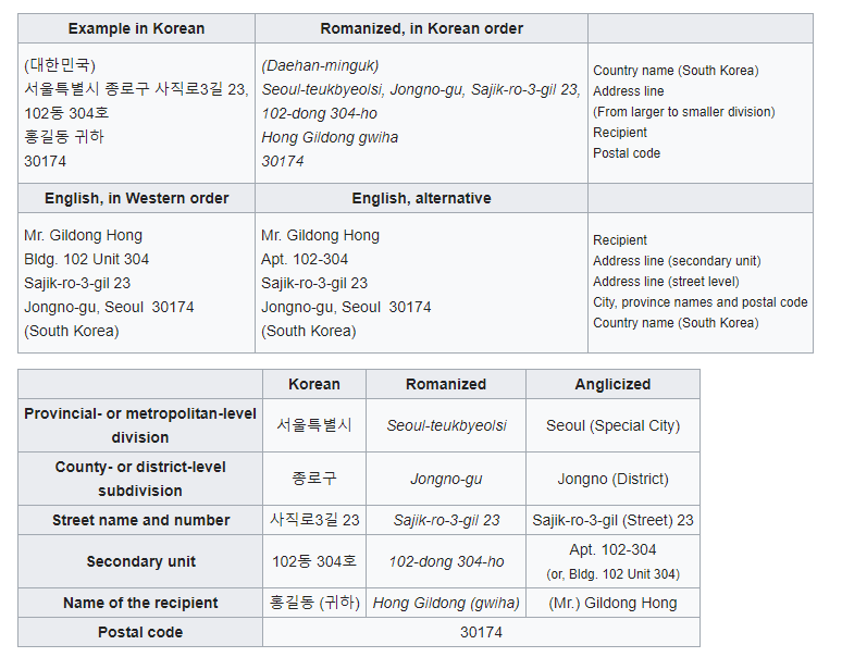
Websites in English may show the American format of addresses, but do know that in Korea, addresses are generally given in the exact reverse order to the US. A good way to remember the order the address is to look for when using GPS 시-구-로-#.
시 (shi) = City
구 (gu) = District
로 (ro) = Road
# = the unit number
*Certain addresses like apartments may also have extra fields like 3길 after the road (로) and before the unit number. This is a street name for residential complexes. Also there may be a “secondary unit” name after the street name. That is in reference to apartment complex building numbers. Most apartment complexes will have numbers on the side of the buildings (see image) to show what building number (like 102동) they are. The 304호 refers to your unit number. If you are staying at an AirBnb apartment, expect to get an address like the example to write on your immigration papers.
**You might also find a lot of people still using the “old” format for addresses. Korea a few years ago went through an address format change, and official documents have moved to the new format (the one I’ve shown), but some blogs and websites may still use the old address. Those addresses will work on the Korean navigation apps.
When navigating to a specific address, I recommend to use the address in Korean, rather than in English. Mostly because outside of Google maps, other map apps won't understand the English address. However, getting to popular well known buildings and tourist attractions should be easy enough through Google maps.
Map apps:
I'll talk a little bit about each of the apps I've tried, and give an example of route information for each to give some parallel comparison.
The examples use the following:
Start: Say Cheese Toast (세이치즈 토스트) A Hokkaido based cheese toast franchise, with a location in Hongdae
마포구 홍익로 2길 7
7 Hongik-ro 2-gil Mapo-gu, Seoul (would be the English equivalent search)
End: Itaewon station.
A specific district for foreigners, with lots of different ethnic foods, Western-style clubs and bars. It was near the Yongsan American army base, which has since relocated to Camp Humphreys in Pyeongtaek.
***Just to note, I wouldn’t call my examples thorough, because I don’t live in Korea currently. Really, it was just me using predetermined start and end addresses, and testing the UI using both my knowledge of Korean and English (And my background as an app developer) to see which apps might work best from a tourist perspective, who might have little knowledge of the Korean language. When I go to Korea next, I’ll try to update this guide to be a bit more visual and descriptive.
Google Maps
One of the biggest things people will say about using map apps and transit in Korea is "Don't use Google Maps. It's the worst" They are not wrong, as when location based apps really started to rise, Google couldn't get into the Korean market due to a lot of government restrictions and national security reasons. But Korea's abundance of public transit APIs made it easy to get cheap access into the transit database.
With simple tasks like getting from one subway station in Seoul to another, it is quite easy to stick with google maps, as well as a good number of bus routes in Seoul. For very short term travelers in Korea, Google maps might be the only app you need.
That being said, Google maps is not the best transportation app, and having another option even as backup may be to your benefit.
Example:
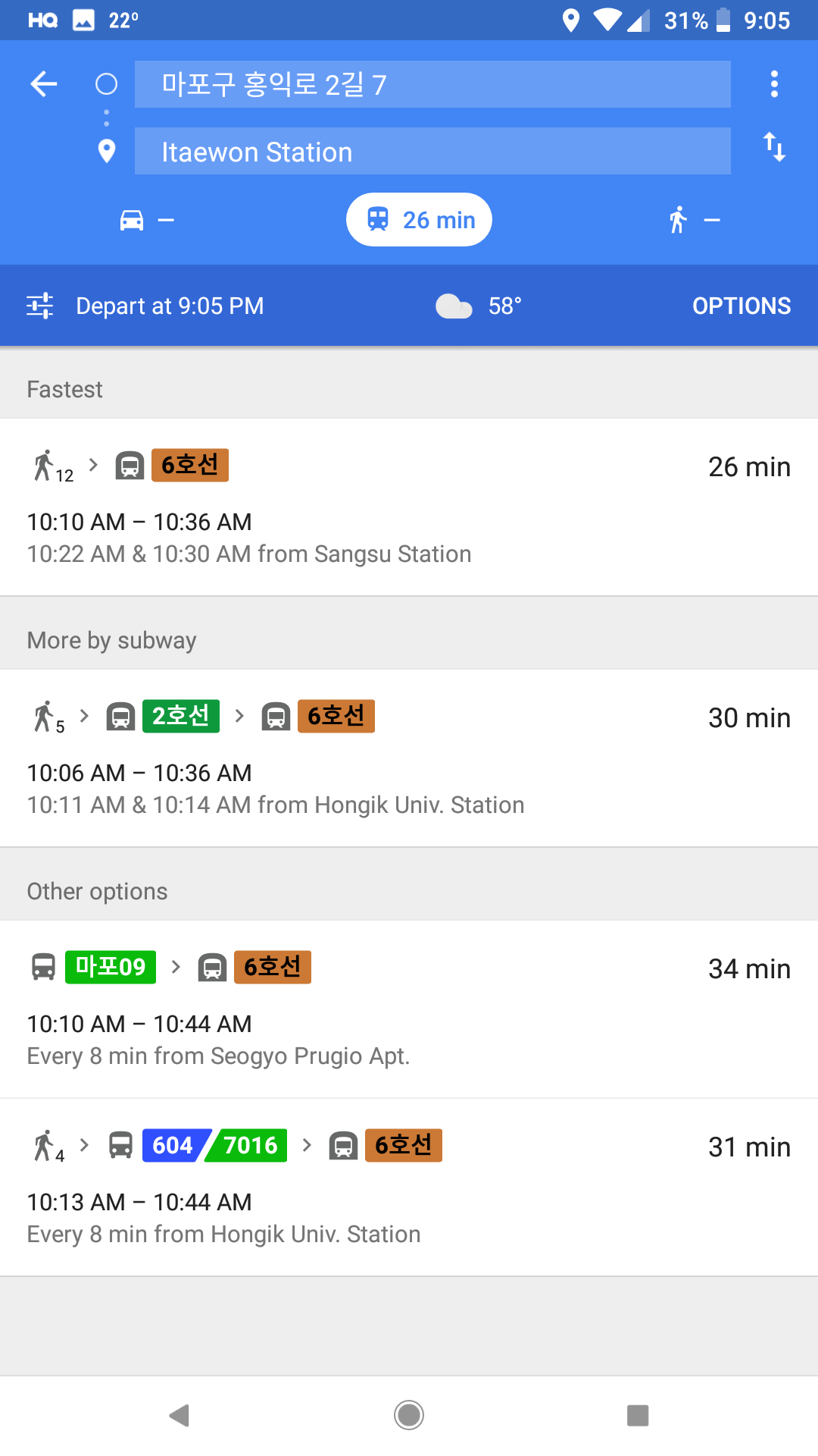
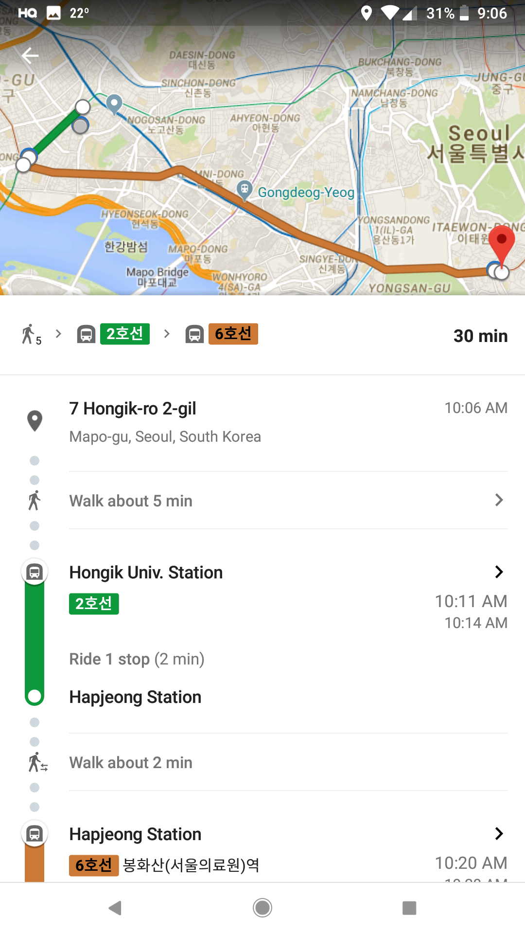
Google maps actually does a pretty good job here, able to accept the Korean address, a search for a specific station in English, and give me the results I expected, an option between walking to take the 6 line, or taking a 2 line and transfer to the 6 line.
Kakao maps
One of the common recommendations for navigation apps
I believe it wasn't until recent that English became a usable language setting in the app, but from my example test, you can see that it still needs some work. If you can read hangul, Kakao maps might be for you.
Kakao also has bus and subway info. Unfortunately, this also means you need to download those apps as well. It would be nice to have these services integrated into the map app as one, but that's not really how the app community works in Korea.
Example:
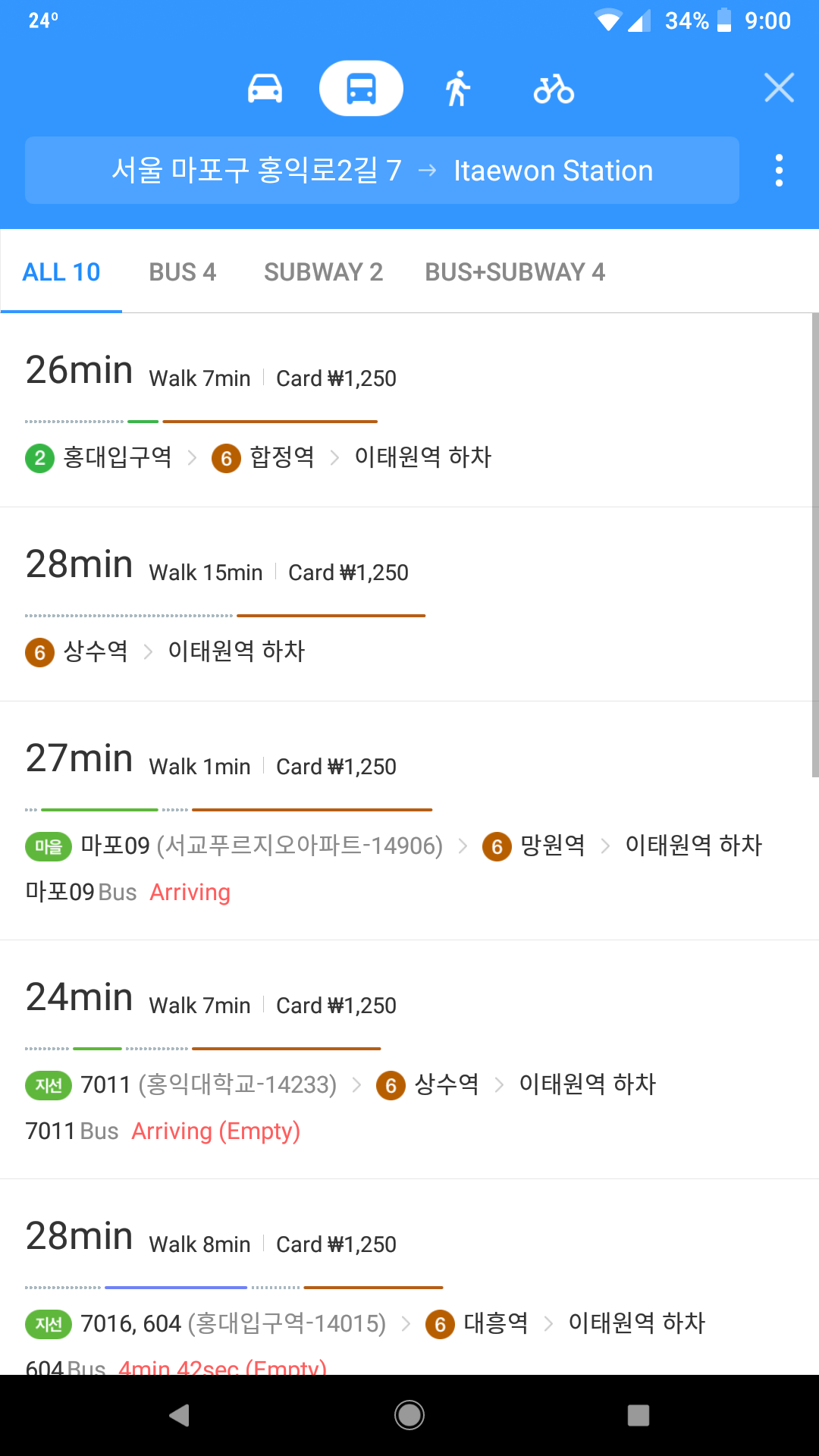
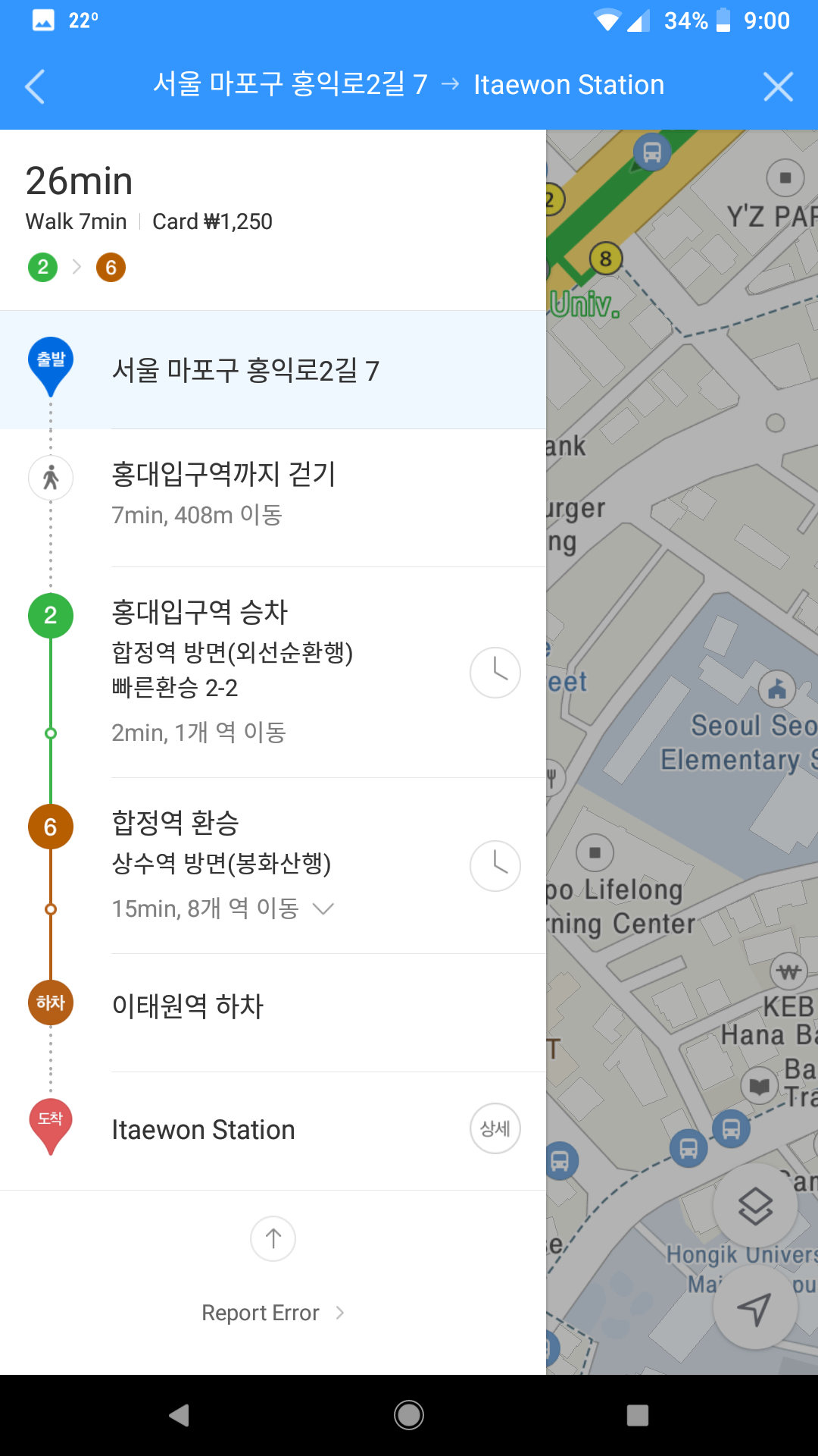
Kakao does just as well, obviously it is able to take Korean addresses, and even searches done in English worked fine with the recently added English language. Unfortunately, it does seem like at this time (Late March 2018), there is still a lot of work they need to do in making English widely usable within the app. Although your searches and the map text show English, directions are still mainly in Korean, so users with limited ability to read hangul may want to avoid Kakao maps at this time.
Naver maps
Naver maps, in the recent times has fallen out of some love with all the Kakao integration, but still a really good option for navigation. Unlike Kakao maps, Naver does offer a website version of its map services, but it’s only in Korean.
Example:
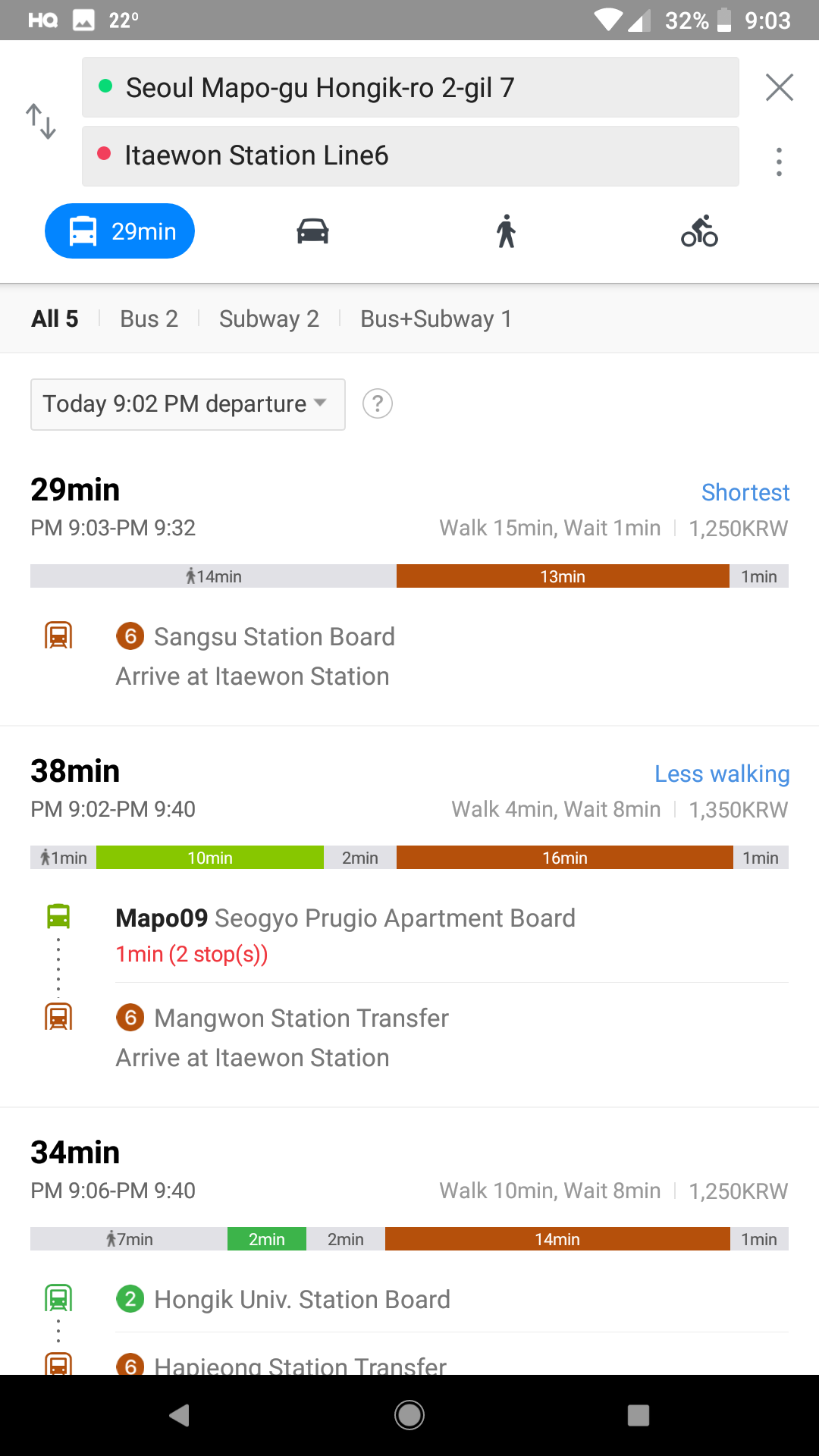
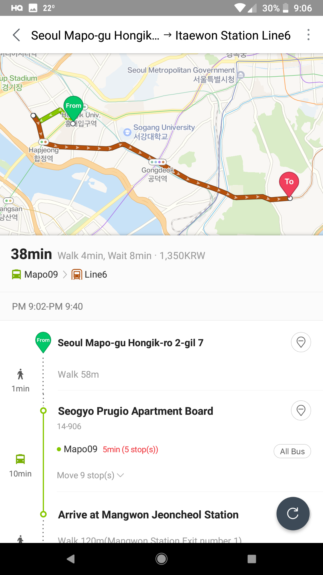
From the 3 maps, Naver makes the strongest showing in my opinion. Although I fed the starting address in its Korean form, the results returned the correct address in English, and produced proper results when I searched for Itaewon station in English. I also noticed that the app tries to follow your system default language (in Android) if it supports it, as opposed to Kakao maps where you might need to dig into the settings to change your language settings to English. The map for Naver even shows both English and Korean, which is a plus in my book. Overall, I’d say Naver maps was the best map I tested of the three.
Subway-only apps
Subway maps live to accomplish one thing. Showing you paths from one station to another with time stamps, cost, transfer, and schedule. If you are pretty good with directions, and know where you're going, or just want to meet someone at another station, the simplest way to do so is through subway apps, because all good subway maps will allow you to tap your starting destination, and your ending destination.
Coming soon!
I personally don’t swear by any specific maps, but I can give a recommendation for a subway-only app